
1. INTRODUCTION
The idea for the San Francisco Mission Creek Bikeway and Greenbelt (MCB) was conceived in 1991 when the Southern Pacific Railroad abandoned the Mission Creek line along Division Street. The remaining swath of continuous open land presented an opportunity to revitalize this historic corridor to meet the changing needs of San Francisco's post-industrial neighborhoods. From the intersection of 16th and Harrison Streets in the Northeast Mission district, along Treat Avenue and Division Street, around and through the 8th and Townsend Circle, to the Caltrain tracks bordering Mission Bay, the abandoned railroad corridor traces the route of the once navigable Mission Creek. In addition to salvaging an important transportation asset, the Bikeway and Greenbelt Project also provides an opportunity to educate the public about the natural drainage hidden beneath the City streets and to promote the environmental stewardship of the San Francisco Bay and Estuary.
By providing a safe route connecting the Mission District to Mission Bay, the Mission Creek Bikeway has the potential to relieve congestion by making the eastern waterfront more accessible to the residential neighborhoods to the west. Creating a human-scaled environment in the midst of elevated freeways and industrial buildings, a bikeway and greenbelt will encourage greater bicycle/ pedestrian activity while improving aesthetics along the historic Mission Creek rail corridor.
Project Description
Specifically, the Project's goal is to provide a continuous bicycle/ pedestrian route linking the corner of 16th and Harrison to the bikeway planned along the south side of the Mission Creek Channel, the last remnant of what was once Mission Creek. Between 16th St. and Bryant, modifications are proposed to Treat Ave. including traffic calming, landscaping, and restrictions on through traffic to allow the creation of a "bicycle boulevard." Between Bryant St. and Vermont, a Class I, off street bikeway is proposed along the south side of Division under the Central Freeway, utilizing private land that would need to be acquired via purchase or land trade (see Land Acquisition Strategies, page 38). After Vermont, striped bike lanes, a Class I bikeway and other traffic calming projects are proposed on either side of the 8th and Townsend Circle to De Haro Street. From here, a path through a planned residential development would lead users to a proposed bicycle/ pedestrian bridge crossing both 7th St. and the Caltrain tracks, connecting directly to the planned Mission Creek Park, with its bicycle and pedestrian paths leading to Pac Bell Park and the Embarcadero Promenade.
Historic Setting
Before the Spanish arrived at Mission Bay in 1775, the Ohlone Indians had inhabited the area for at least 5000 years. The Ohlone harvested mussels and fish, paddling up Mission Creek in tule reed canoes to what is now the Mission District. At this time, most of what is now Market St. and SOMA was sand dunes, with extensive marshes and wetlands lining the banks of the Creek. When the Spanish arrived, Mission Bay and the Creek flowing into it provided a safe harbor for the new immigrants, who made a permanent settlement slightly uphill, along the fresh water stream flowing from Twin Peaks into the fertile estuary. The main road they constructed from the Mission to the Bay became Center Street and eventually 16th Street.
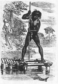
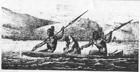
Living conditions at the Mission were deteriorating on their own when the Mexican revolution of 1810 ended the stipends to the Spanish Fathers and a generous system of land grants was established to assist new Mexican settlers. A few families laid claim to most of the land around the Mission: the Bernals claimed Potrero Viejo (from Islais Creek to Hunters Point) and the De Haros claimed the Potrero Nuevo (from Mission Creek to Islais Creek). The map that accompanied the De Haro land grant shows intimate details of the river and shoreline. (see Exhibit 1 below) The De Haro rancho was located near 15th and Potrero, two blocks uphill from the river. Today a collection of fine brick buildings marks the location.
|
|
|
Exhibit 1: De Haro Land Grant Map (bounded by Mission Creek to the north, and Islais Creek to the south) and European depictions of Ohlone
Once the Gold Rush hit, squatters took possession of nearly everything that wasn't occupied, and very few of the large Mexican land grants survived intact.
The primary commercial activity developed along the city waterfront and harbors. Mission Creek was designated a navigable stream and a drawbridge constructed where Potrero crossed over to Brannan which allowed boats to reach as far inland as Center (16th) Street, where another major crossing was constructed (see Exhibit 2 below).
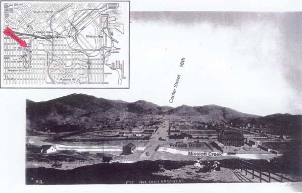
Exhibit 2: This drawing circa 1860 depicts the bridge over Mission Creek at 16th Street where the entrance to the Mission Creek Bikeway is proposed. This drawing inspired the mosaic mural installed at the same corner.
In the late 1860s a railroad was built from San Jose to San Francisco, entering from the south through the Bernal Gap (San Jose Ave) and continuing north along the east side of Mission Creek on what is Harrison Street today. Exhibit 3 (following page) shows the railroad on the US Coast and Geodetic Map of 1869 next to a recent map of the City. The 1869 map is particularly informative because enough of the current street grid had been constructed to be useful as a reference today, yet the river was still present on the surface.
Shortly thereafter Mission Bay was filled in with sand and debris, as was the fate of most of San Francisco's waterfront property, and the Creek was buried in culverts and forgotten. The name "Division Street," was given to the street later built on top of the river itself, because it divided the three street grid systems of SOMA, the Mission, and Potrero Hill. The rail corridor that was built alongside the river preserved a lasting reminder of the natural terrain, nearly hidden by the rectangular street grid that obliterated everything else. The swath of land which remains, provides an educational tool and opportunity to remind us of the river underground, and the natural environment which is so often lost in a dense urban setting.

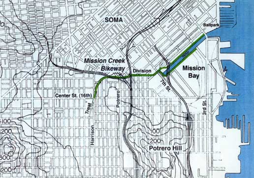
Exhibit 3: These maps show the US Coast and Geodetic Survey of 1869 (above) and a current map of San Francisco (below) with the Mission Creek Bikeway highlighted in green. The 1869 map shows the two bridges over Mission Creek at 16th Street and Potrero. The small island near the mouth of Mission Creek, where it opened into the Bay, is where the Townsend Traffic Circle is today. Note that the river delineates the northwestern extent of Potrero Nuevo.
Current Setting
As of 2002, much of the former Southern Pacific railroad land has been purchased by private interests and appropriated for parking lots, making such a bikeway and greenbelt project more difficult today than it would have been a decade ago, when the railroad abandoned their corridor. Fortunately most of the land has not been developed, due to its alignment over sewer easements and under the elevated Central Freeway, and the majority of the corridor remains intact today. Where development over the former rails has occurred, sufficient street right-of-way exists to accommodate a bikeway.
This concept plan proposes to utilize key sections of this abandoned railroad corridor through San Francisco's eastern industrial districts, where redevelopment efforts are changing the area's character into high-density residential and commercial mixed use.
These land use changes are primarily due to:
1. shifts in business from industrial to high tech;
2. UCSF campus development at Mission Bay;
3. an increasing demand for housing.
This area is the focus of renewed interest and intense development efforts because it is one of the few areas in San Francisco where significant land is available for development (see Exhibit 4: City Map with industrial districts & MCB highlighted).
Development at Mission Bay is coordinated through a redevelopment process with significant public oversight and planning. Yet the surrounding commercial districts of South of Market, the Northeast Mission, Showplace Square and the 3rd Street Corridor east of Potrero Hill, have changed rapidly in the last 5 years, independent of a coordinated effort by the San Francisco Planning Department. Most of the empty lots and derelict warehouses have been replaced by private developers with multi-story residential and commercial buildings bringing many more people to the area, adding to already severe traffic congestion.
The rapid pace of recent land use changes in the City's southeast quadrant has resulted in concern by citizens and policymakers alike. Better urban planning is needed, to avoid potential conflicts between residential and industrial uses, to preserve land for future development, and to mitigate the consequences of increased density and population. The SF City Planning Department has undertaken a number of long range planning efforts described in their 2002 report "Profiles of Community Planning Areas: San Francisco's Eastern Neighborhoods." Exhibit 5: Citywide Action Plan is taken from this report. The MCB is located in the very center of this redevelopment and planning effort, as can be seen in the exhibits on the following page.
At the east end, Mission Bay, the 4th St. Caltrain Station, and Pac Bell Park are new and important destinations that could be made more accessible to SF residents by implementing the Mission Creek Bikeway. But just as important, bicycle commuters crossing Division Street (say from the Civic Center to Potrero Hill or Showplace Square) will also benefit from improvements to the complex intersections, which are difficult to avoid and confusing for all

Exhibit 4: San Francisco Map with Industrial Districts and Mission Creek Bikeway
Exhibit 5: SF City Planning - Citywide Action Plan
users of the route (autos, trucks, bikes and pedestrians). The Showplace Square area at the 8th and Townsend Circle has become a busy pedestrian area in recent years, which will only increase with the completion of large, new housing projects and ground-floor retail slated for the area.
Plans for Mission Bay call for an impressive network of bicycle routes within the boundaries of the redevelopment area (See Appendix A Mission Bay Bicycle and Pedestrian Network). Yet safe access for bicyclists and pedestrians traveling between Mission Bay and other neighborhoods has not been a priority for the Mission Bay planning effort. There is currently only one dedicated bicycle facility connecting Mission Bay with adjacent neighborhoods — bike lanes at the 16th St. crossing. As of June 2002, these bike lanes are still under review by the SF DPT and the Peninsula Corridor Joint Powers Board, and may not be approved. The lack of non-motorized connections is distressing given the natural and artificial boundaries separating Mission Bay from SOMA and the Mission District, and the few crossings of the railroad tracks that provide access to this new neighborhood. The bridge proposed to cross the Caltrain tracks and 7th Street at Berry, as part of the Mission Creek Bikeway Project, would do much to improve non-motorized access to Mission Bay, especially from Showplace Square and neighborhoods to the west.
Future of the Corridor
How this vital artery is handled over the next decade will have a great impact on whether this central part of the City becomes a more livable community and integrates the neighborhoods surrounding it, or whether it increasingly becomes a physical barrier dividing these neighborhoods from one another.
Today Division St. is unparalleled as a transportation route. The major street grids of South of Market, the Mission, and Potrero Hill all intersect here, with 5 or 6 major thoroughfares coalescing along Division Street in several complex intersections. Division is too important a corridor to neglect the needs of bicyclists and pedestrians. New safety measures are needed, especially in light of the fact that the section of Division between Bryant St. and the Townsend Traffic Circle is a key link in the SF Bicycle Plan: Bike Route 36 (see SF Bike Map, Appendix B).
As difficult as it may seem to integrate more bicycles into this busy traffic pattern, there are only a few difficult intersections to address along the one-mile corridor, and these same intersections need improvements for automobiles as well. An alternative route, along Alameda Street, was considered during this study, which provides a less direct route parallel to Division (see page 20). But it does not provide the linkage to the South of Market street grid, the reason that Division is so crucial to automobile, and increasingly, to bicycle and pedestrian transportation.
As development in the area moves forward, and increased automobile traffic replaces the slow moving rail cars along Division Street, there is potential that the historic river and rail corridor will be forgotten amidst a maze of freeways and parking lots. There is another vision however.
The former Mission Creek Corridor could become a central bicycle/ pedestrian artery through San Francisco's newest neighborhoods. Strips and pockets of greenery could soften the industrial landscape, highlighting a safe route through a hostile environment for those on bike or foot, and rekindling an awareness of this once thriving riparian habitat.
A Mission Creek Bikeway and Greenbelt could be the pride of San Francisco. However, unless measures are taken soon to coordinate planning efforts in order to preserve this swath of land, the opportunity could be lost forever amidst rapidly expanding car-oriented development. The hope is that this project will act as a catalyst to revitalize the neighborhoods it passes through, inspiring private individuals and companies to combine their efforts with those of the City to create a world-class bikeway and greenbelt along the former river that nurtured the original settlement of San Francisco.
Exhibit 6: Air photo taken in the early 1990's includes the entrance to the Mission Creek Bikeway at the far left, where Treat Ave. (and the river) cross diagonally over the rectangular street grid at Harrison and 16th. The harbor channel of Mission Bay can be seen at the upper right.