
< previous table of contents next >
3. TECHNICAL DESIGN ANALYSIS
The Mission Creek Bikeway Project can be divided into four major segments, each with their own specific technical characteristics. For the segments with multiple alternatives, Alternative #1 is presented as the preferred alternative. In some cases, Alternative #2 could be considered as a first phase of improving a given segment. The segments are divided as follows:
1. Treat Avenue Bicycle Boulevard (Harrison to Bryant)
2. Division Street Bikeway (Bryant to Vermont)
3. Eighth and Townsend Circle (Vermont to Berry)
4. Crossing to Mission Bay (Berry to Mission Creek Park Bike Path)
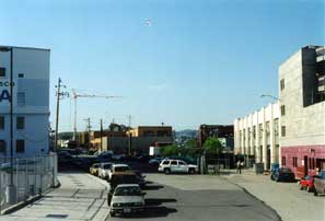
Treat Avenue Bicycle Boulevard
Treat Ave. looking south (SPCA Bldg. on left) Treat Ave. looking northeast, additional 15 foot
SF AC&C dog park in center strip was added to ROW in 1996.
Treat Avenue is a relatively quiet street, curving to the northeast through a series of large commercial and industrial buildings. The primary conflict with bicyclists and pedestrians would be truck loading and unloading. The SF Animal Control and SPCA facilities are located at the south end of the Treat Ave. segment, and there is concern from staff that volunteers walking dogs could conflict with bicycle traffic. Because of constrained width, potential conflicts at loading zones, and a desire to provide adequate separation between bicyclists and pedestrians, the design team decided to plan the Treat Ave. section as a bicycle boulevard.
Bicycle boulevards are considered Class III bicycle facilities, and have been implemented successfully in many communities all over California, including a bicycle boulevard network in Berkeley and a regional bicycle boulevard along Bryant St. in Palo Alto. Bicycle boulevards are typically flat, low-traffic streets that are protected by stop signs on cross streets. The removal of stop signs along the bicycle boulevard itself provides bicyclists priority at intersections and allows them to maintain momentum -- a critical design characteristic that makes bicycle transportation more efficient and appealing. There is usually at least one intersection along a bicycle boulevard that prohibits through motor vehicles, yet permits through bicycle and pedestrian traffic. This discourages drivers from using the street as a "cut through," and makes the street more attractive for non-motorized users. There are frequently traffic circles at intersections and other traffic calming devices along the street to slow remaining motor vehicle traffic to a safe speed.
Mission Creek Bikeway Entrance at 16th and Harrison
Two perspectives of the 16th and Harrison Bikeway Entrance- note the lack of sidewalks
16th and Harrison Alternative #1: This is the long-term alternative that would create an area of landscaped open space at the entrance of the MCB, resulting in the removal of significant numbers of parking spaces (see exhibits 8, 9 & 10, following pages).
Under Alternative #1, the entrance of the Mission Creek Bikeway and Greenbelt at 16th and Harrison would be designed for bicyclists and pedestrians only, with bollards to prevent motor vehicles entering or exiting Treat Ave. at this location. The design of this entrance allows northbound cyclists on Harrison St. entering the MCB to maintain momentum by providing a wide angle between the bikeway and Harrison St. Cyclists traveling southwest along Treat Ave. wanting to turn left on Harrison will use the bikeway exit, designed to approach Harrison at a 90-degree angle to improve visibility and discourage cyclists from proceeding to the corner of 16th and Harrison on the wrong side of the street.
A new island would be constructed between the entrance and exit at Harrison St., providing an opportunity for landscaping. A new sidewalk would be constructed beginning at the northeast corner of 16th St. and Harrison passing under the existing Mission Creek mural, and continuing north along the east side of Treat Ave. to 15th Street. An additional sidewalk will be installed on the east side of Harrison St. The planning team considered the location of the loading dock at Quinn Printing in its design. Curb cuts across the sidewalk maintain motor vehicle access to this business. Use of this loading dock is infrequent and vehicles are not expected to interrupt pedestrian traffic on a regular basis.
16th and Harrison Alternative #2: This is the short-term, or interim, strategy that would provide basic bike/ pedestrian facilities with minimal landscaping to maintain use of a portion of this area for parking (see exhibit 10).
Under Alternative #2, 15th Street at Harrison would become a one-way entrance to a new parking facility, with 10 parking spaces being kept along the north side of 15th St. between Harrison and Treat. Twenty diagonal parking spaces would also be installed alongside the bike path. Cars would exit this lot at Treat and Harrison at a separate exit from the bikeway.
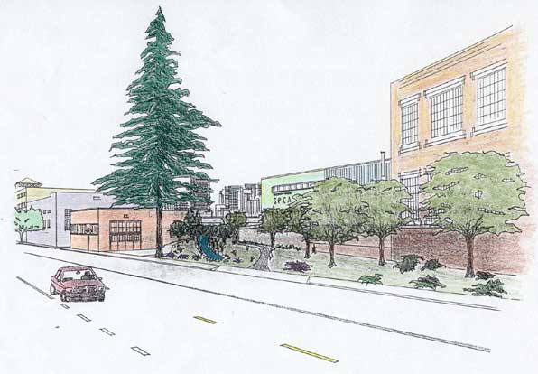
Exhibit 8: Rendering of bikeway entrance at 16th and Harrison
by Ivor Thomas, UCB Planting Design Course (similar to Alternative #1)
Exhibit 9: Treat Ave. Bike Blvd. Entrance Alternative #1 w/ landscaping

Exhibit 10: Treat Ave. Bike Blvd. Entrance Alternative #2 with parking
The Treat Avenue bicycle boulevard section could be implemented in phases, starting with Alternative #2 in the near term while seeking funding for landscaping improvements and locations for parking replacement in the longer term.
Treat Ave. would be closed to through traffic just north of 15th Street between the AC&C and MUNI buildings, with a turnaround area for cars and trucks located between AC&C and SPCA. This would be accomplished with a line of bollards, with one in the middle being of a type that can be removed or retracted to ensure emergency vehicle access. The design will ensure that neighboring businesses will continue to have unfettered access to loading docks, parking lots and other vehicle entrances while minimizing conflicts with non-motorized traffic by reducing the use of Treat as a high-speed short cut for autos.
Florida St. could either be closed at Treat Ave. using a similar design to the Alabama St. closure, or traffic calmed using bollards and bulb-outs to maintain motor vehicle access.
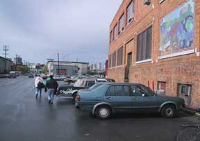
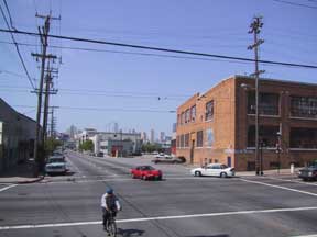
Division Street Bikeway

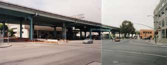
Division St. looking east Byer Parking lot on the former rail corridor
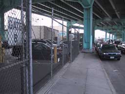
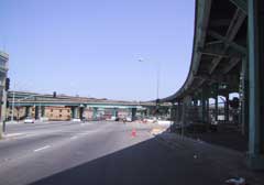
The section of Division Street under the elevated Central Freeway between Bryant and Potrero features the most hostile present conditions for both bicyclists and pedestrians along the analyzed route. The minimal sidewalk width interrupted by frequent freeway columns, lack of bicycle lanes, heavy traffic, and noise from the freeway overhead all contribute to a poor environment for non-motorized traffic.
Adding to the poor conditions, Division "divides" two different street grid systems. Five roadways intersect at three different locations on Division, including the intersections at Bryant and Potrero, which the MCB must negotiate. Yet the confluence of roads at Division is also what is most valuable about the corridor for both autos and bicycles, providing access to numerous streets in the SOMA and Northeast Mission Districts. In addition, the presence of rail activity along Division for over 120 years facilitated the removal of many barriers and potential conflicts with automobiles that would ordinarily exist in such a dense urban setting. As an example, many streets that abut Division have already been closed or vacated and sold to adjacent landowners, such as York, Hampshire, and Utah.
The success of this section (and the entire project) will depend on the ability to acquire certain parcels from Byer Properties (see Land Acquisition Strategies, page 38). However, if acquiring private land along Division St. proves difficult or impossible, there are alternatives.
Alameda St. at Bryant looking east
Alternative to Division Street: This option would use Alameda Street, one block to the south, as a detour between Bryant and San Bruno that would avoid the busy intersections and constrained widths along Division. Yet problems exist with this route as well. Alameda is out of the way, passes behind numerous industrial properties with heavy truck activity, and would not follow the historical route of either the Mission Creek or the rail line that ran along it. In addition, Alameda St. would not provide access between the street grids of South of Market and the Mission District, an invaluable characteristic of Division Street.
This option may work as an interim solution if negotiations with Byer Properties take longer than anticipated, and other sections of the project are ready to be implemented. However, the acquisition of key parcels along Division St. must remain a central focus of the project, to ensure a safe, direct, aesthetically pleasing facility.
Bryant Street Crossing
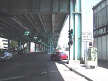
Photo of Treat Ave. (on the left) intersecting Bryant St. Blind corner (Division at Bryant) (in foreground). Division and the Central Freeway are Right turn arrow signal proposed on the right.
Bryant St. is a relatively high capacity arterial street with blind corners at Division and Treat, and thus care should be taken in designing a safe crossing for the Mission Creek Bikeway. A MUNI bus stop is currently located in front of the Byer retail outlet pictured above. After reviewing a number of options for this intersection, the planning team feels that two different designs should be analyzed for feasibility in phase II final design.
Bryant St. Crossing Alternative #1: This option would route trail users across a separate, newly signalized intersection at Treat Avenue, where they would cross at a designated signal phase (see Exhibit 11 on next page).
The advantages of this alternative include: designing the bikeway to accommodate predicted use along the most direct alignment; enabling bikeway users to wait for a green light at a less congested (and polluted) location; and maintaining good sight lines. Disadvantages include: greater cost to install new signal heads; concerns about cars possibly disobeying the right turn red arrow on Division at Bryant; and possible driver confusion about two signalized intersections in such close proximity.
Bryant St. Crossing Alternative #2: This option would route trail users to the intersection at Division and Bryant where they would utilize the existing crosswalk within a designated phase (see Exhibit 12).
The advantages of this alternative include: consolidating bicycle/ pedestrian movements into one alignment; making use of an existing signal and intersection; and improved sight lines at the intersection itself. Disadvantages include: forcing bicyclists to make a left turn onto a sidewalk just prior to a blind spot created by the Byer building; making bike and pedestrian traffic cross Bryant at a blind spot created by a freeway column just west of the intersection; and detouring from the most direct route across Bryant Street, which many cyclists and pedestrians will, and do, use anyway.
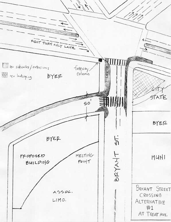
Exhibit 11: Bryant Street Crossing Alternative #1: Crossing at Treat Ave.
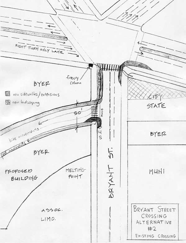
Exhibit 12: Bryant Street Crossing Alternative #2: Existing Crossing at Division
For either or both alternatives the following improvements would be made:
Additional improvements with Alternative #1 would include:
Additional improvements with Alternative #2 would include:
DPT Bicycle Program and Parisi Associates engineering staff analyzed the effects of providing a dedicated phase for trail users on automobile level of service during peak hours, and the result was an increased delay of 21 seconds, shifting LOS at this intersection from E to F. Not providing a dedicated phase for trail users would allow LOS to remain at E. However, safety would suffer, as cars making a right turn would conflict with bicyclists and pedestrians. An "early release phase" was analyzed, in which trail users would receive a green signal in advance of eastbound traffic on Division, allowing bicyclists and pedestrians waiting at the corner to enter the intersection prior to autos. Using an early release phase in place of a dedicated phase would maintain auto LOS at level E, but would endanger trail users due to conflicts between cars turning right from Division onto Bryant, exacerbated by the blind spot created by the freeway column.
After people cross Bryant, a triangular parcel owned by the City and Caltrans (currently leased to Byer Properties) provides land for a pathway with minimal landscaping up to a point halfway between Bryant and Potrero. After this point, land would need to be acquired or traded to continue the path eastward. (See Land Acquisition Strategies page 38)
Section Beneath Central Freeway Between Bryant and Potrero
This section is constrained between the freeway columns in the sidewalk and the existing buildings to the south. Further compounding these constraints are two automatic gates and driveways from parking and loading areas for Hostess and Byer operations onto Division Street, crossing the proposed alignment of the bikeway.
The preferred solution to accommodate a bikeway through this area has two elements:
The most constrained location occurs mid-block, where a freeway column, a throughway between two parking lots, and a wall pinch the available right-of-way down significantly. Either the path would have to be built within these constraints, maintaining existing vehicle access between the two parking lots or vehicle access would be eliminated, allowing the bikeway to remain at a standard width. Most likely, the path would have to narrow at this location regardless, as a wider right-of-way would conflict with loading docks located just south of the constrained area. Another driveway just west of Potrero crosses the path but without the same space constraints. Alternatives are shown in Exhibit 13 on the following page.

Truck loading, freeway columns, and driveways make this section of Division a challenge to accommodate a standard width bikeway.
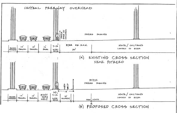
Exhibit 13: Cross sections of Division St. between Bryant and Potrero beneath Central Freeway- various alternatives are depicted
Potrero Avenue Crossing
Division just west of Potrero- Division and Potrero looking SE: The construction of a right turn only lane proposed here new pedestrian island is underway to the left.
The intersection of Potrero, Division, 10th, and Brannan Streets involves coordination of 22 separate lanes of traffic. Understandably, this location is notoriously difficult for both automobiles and non-motorized traffic in its present state. Crossing this major arterial intersection, along the south side of Division, involves crossing seven lanes of traffic. However, the proposed new traffic signals and refuge islands will facilitate bicyclist and pedestrian movements.
A modification to the signal's phasing to prohibit right and left turns from Division onto Potrero while trail users have a green light is essential to improve safety, yet would result in automobile LOS F using current analysis techniques. The construction of a bicycle/ pedestrian over-crossing would be costly and space-intensive, yet would greatly improve safety at this complex intersection. This concept plan does not include feasibility information on such a structure.
At Potrero, a design similar to Bryant St. Crossing Alternative #2 would be implemented with an expanded bulb-out of the sidewalk, and a new right turn only lane added by removing the 12-foot parking lane along the south side of Division (see Exhibit 14, next page). A dedicated signal phase for bicyclists and pedestrians would be implemented, using new bicycle and pedestrian signal heads, and a new right turn arrow signal installed facing eastbound traffic on Division.
A new pedestrian island is currently being constructed under the supervision of DPT to improve the safety of pedestrians crossing Potrero (See Appendix D for design specifications). This island would be modified to accommodate bicyclists and extended south as part of implementation of the MCB. In addition, the island to the east would be improved to provide an additional refuge for bicyclists and pedestrians. DPT Bicycle Program and Parisi Associates engineering staff report that adding a dedicated phase for trail traffic would improve safety for bicyclists and pedestrians yet reduce PM peak hour automobile LOS from D to F with a delay of 82 seconds.
Exhibit 14: Potrero Ave. Intersection Diagram
The following improvements are proposed for the Potrero Ave. Crossing:
It is also recommended that further study of the Potrero Crossing be conducted, in order to identify how traffic could be simplified. Currently, there is excess street space in this intersection, adding to driver confusion and unpredictable traffic movements. Reducing the number of vehicle lanes entering from 10th Street by creating a right turn only lane is one possibility that should be examined. A comprehensive analysis of this intersection is clearly needed, yet this analysis is not within the scope of this concept plan.
The planning team recommends that such an analysis take place within the phase II final design for the Mission Creek Project, or independently as part of DPT's routine safety improvement studies.
| San Bruno Street Vacation |
 |
Under the MCB proposal, San Bruno Street would be vacated and used to trade for other key parcels. The Dolby Labs building is visible across Division.
The MCB would continue eastward using acquired Byer property adjacent to the public right-of-way between Potrero and San Bruno. The plan proposes vacating San Bruno between Alameda and Division, essentially abandoning this block as a public thoroughfare. Such an action would have multiple benefits (see Land Acquisition Strategies). The street vacation could be part of a land trade between the City and Byer Properties to replace lost parking due to implementation of the bikeway. It will also simplify the flow of traffic and reduce the number of streets that the bikeway will have to cross, improving safety.
8th & Townsend Circle
Townsend Circle looking east SF Critical Mass visits 8th and Townsend Circle; Design Ctr. is visible in background.
After San Bruno, the trail would be routed onto Caltrans-owned property between San Bruno and Vermont, where a pocket park is also proposed. At Vermont, the Class I facility would transition to Class II bike lanes, with eastbound cyclists entering the roadway at the southwest corner of Vermont and Division via a new bulb-out, and pedestrians remaining on the sidewalk. Westbound cyclists leaving the circle would enter a new left turn only bike lane on Division and yield to eastbound traffic before turning left into the bikeway entrance. Motor vehicles would be prohibited from turning left from Division onto Vermont.
An additional pocket park is proposed for the southeast corner of Division and Vermont, which will not provide any specific transportation-related improvement to the area, but will add to the general aesthetic in keeping with the Mission Creek theme. The Bay West Group that controls the lot has offered to contribute some landscaping work and maintenance of this triangle to the project. This also may be one location for artwork and/or a water feature (fountain or pond). Here, there is a distinct feeling of arriving into an open area after being in the shadow of the Central Freeway for several blocks.
The design team agreed early on that bicycles would have to merge with motor vehicle traffic through the circle in order to minimize conflicts with motor vehicles. This is an acceptable route given the slow speeds that characterize traffic around the circle. Pedestrians would follow the existing sidewalks, crossing first Kansas and then Division on the east side of the circle. The center of the circle, which now features a lawn and a statue maintained by the Design Center, could be enhanced with new landscaping and possibly a water feature. On a historical note, the 8th and Townsend traffic circle marks the location of a prehistoric island in the middle of Mission Creek just before it emptied into Mission Bay.
(See Exhibit 3: 1869 Map, page 4).
Two alternatives present themselves east of the 8th and Townsend Circle.
Division East of Circle
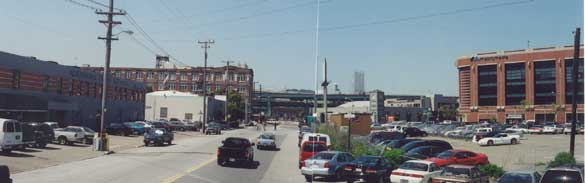
Photo taken from King, De Haro, and Division looking west toward 8th and Townsend Circle
Division East of Circle Alternative #1: This option would create a Class I bikeway starting on the east side of the circle, with a bicycle only entrance featuring a bulb-out with a curb cut and bollards to keep motor vehicles out (See Exhibit 15, following page).
Alternative #1 proposes a design that is common in urban areas in the Netherlands, where separate sidewalks and bikeways are built parallel to the street, and are separated by grade and bollards. Such an "Amsterdam-style" Class I bikeway is proposed along the north side of Division adjacent to and/or utilizing a portion of the 20-foot sidewalk, planned as part of the 675 Townsend development, which will feature street level retail with housing above. This design would necessitate removal of on street parking on the north side of Division between the circle and King St. in order to install a bikeway parallel to the sidewalk. It would also require limiting access to King St. using a line of bollards to eliminate conflicts with vehicles at this intersection. The sidewalk would be separated from the bikeway with a small curb, as well as a line of bollards to clarify rights-of-way to be used by bicyclists and pedestrians.
A special design would be required to maintain the existing MUNI stop on the north side of Division, possibly narrowing both bikeway and sidewalk in this area and providing a pedestrian refuge to the south in which to locate the bus shelter. If this proves infeasible, it may require moving the bus stop to a different location altogether.
The proposed design along this section of Division is not standard in the U.S. and would require approval from the SF DPT. Conflicts may arise at the circle between eastbound bicyclists entering the Class I route and westbound drivers entering the traffic circle from Division. If this design is ultimately selected, it is imperative that careful planning of the entrance to the bikeway be conducted to minimize conflicts with motor vehicles, and encourage predictable behavior from all roadway users.
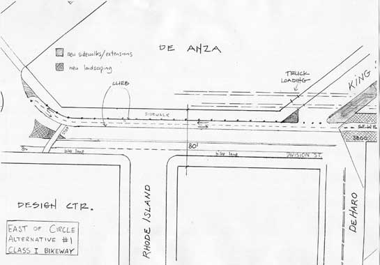
Exhibit 15: Alternative #1 - Class I bikeway east of circle
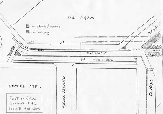
Exhibit 16:Alternative #2 - Class II bike lanes east of circle
Under this alternative the bikeway would proceed due east, south of a line of bollards that would be retractable/removable by emergency personnel as well as retail tenants of 675 Townsend. Motor vehicles will still have access to this block of King St. via 7th Street. The 675 Townsend development plans to install a loading dock on King St. near Division, but it appears that this entrance will not conflict with the trail. However, due to the proximity of the loading dock to the trail, there are still issues to be worked out with the developer regarding turning radii and large truck access (Refer to Appendix I: 675 Townsend Ground Floor Plan).
Division East of Circle Alternative #2: This option shown in Exhibit 16 would install bike lanes along this block to connect with the Class I through the 601 King St. development. Stop signs would be installed at the corner of Division and De Haro.
Alternative #2 would place bicyclists within on-street bike lanes for this block. This alternative would simplify traffic movements on the east side of the Circle; yet create potential conflicts for eastbound cyclists at De Haro.
Because the 675 Townsend project will be under construction shortly, an opportunity exists to include construction of the bikeway as part of the developers sidewalk work. DPT should finalize the design review process in time to include this in De Anza's construction schedule.
After crossing King St. the bikeway will continue along the sewer easement as part of the 601 King St. development, which is being designed, constructed, and maintained by the developer: AF Evans (See Exhibit 17 below)
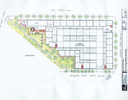
Exhibit 17: 601 King St. Development Ground Floor Plan (with bikeway included)
Crossing to Mission Bay

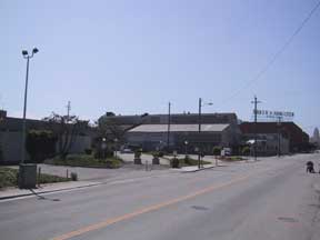
Corner of 7th St. and Berry looking east toward 7th St. 601 King Development will replace Mission Bay/ Commons Crossing building in center of photo
The crossing of Seventh Street and the Caltrain tracks is crucial to a continuous corridor connecting to the Mission Bay Development. Because space limitations prevent the addition of bike lanes as part of the Commons Crossing, California PUC regulations allow no new at-grade crossings of active rail lines, and because of the heavy volume of rail traffic through the area, there is a clear need for a bicycle/ pedestrian bridge to Mission Bay from Berry Street. Such a structure is likely to cost several million dollars. In the near term, the bikeway could be detoured to the planned Commons grade crossing along the west side of 7th Street. Such a detour should be considered temporary; a grade-separated structure is the only solution that would provide direct bicycle/ pedestrian access to the Mission Bay development from neighborhoods to the south and west.
Mission Bay Crossing Alternative #1: This option proposes a bicycle and pedestrian overpass from Berry St. to Mission Creek Channel (See Exhibit 18 on next page).
Assuming the AF Evans housing project is approved with the greenway element intact, the route will exit onto Berry Street. Under Alternative #1 below (the preferred alternative), this would be the site of a proposed bicycle/pedestrian bridge that would cross 7th St. and the Caltrain tracks. The bridge would curve 90 degrees to the southeast, and land along the southwest tip of the Mission Creek channel, connecting directly to the planned Mission Creek Park Bikeway.
Mission Bay Crossing Alternative #2: This option proposes using a Class I facility along 7th Street through the Commons Crossing (Also on Exhibit 18).
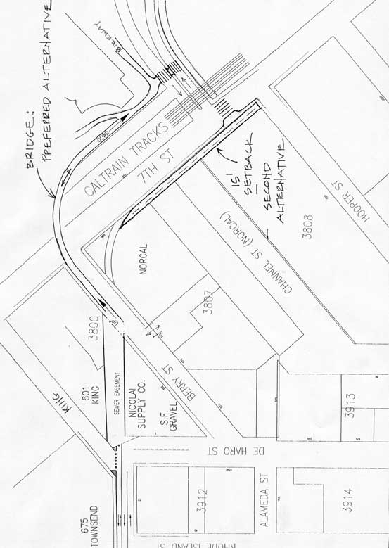
Exhibit 18: Crossing to Mission Bay Alternatives #1: bridge and Alternative #2: bikeway along 7th St. to Commons Crossing
Without one of these project alternatives, bicyclists would make a left onto Berry and proceed southeast on 7th Street for one block to connect with the new Commons Grade Crossing into Mission Bay. Cyclists could make a left turn along with motor vehicles, and stay in the left lane to connect with the proposed left turn pocket (discussed below) or make a "pedestrian-style" left turn using the crosswalk across Seventh St.
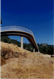
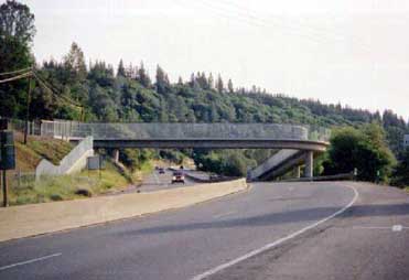
The proposed bridge to Mission Bay might look much like the Sierra Gateway Bridge along the El Dorado Trail east of Placerville, shown above.
Two improvements to current construction plans within Mission Bay would facilitate non-motorized connections through this section:
There are parallel bicycle and pedestrian pathways planned along the south shore of the Channel through Mission Creek Park as part of the Mission Bay Redevelopment Plan. As of May 2002, Catellus' plans call for both to remain unpaved crushed stone paths. The fact that the bicycle pathway is planned to remain unpaved is a concern for the Mission Creek Bikeway planning team. During our public outreach sessions, many people expressed a desire for a continuous bicycle commuter route. Crushed stone is an inadvisable surface for bicycle commuting, because it is slower than asphalt or concrete, and can be impassable during periods of inclement weather.
After proceeding northeast along the pathways, a planned pedestrian bridge will allow crossing to the west end of the channel and the new park. The planning team recommends that changes be made to this structure's design to accommodate mixed use by bicyclists and pedestrians. At this point, trail users with destinations in Mission Bay will continue on the south side, while those with destinations south of Market, including Caltrain, Pac Bell Park, and the Embarcadero Promenade, can cross the bridge. This will avoid having to cross the Third or Fourth St. bridges that include neither bike lanes nor paths.
Modifications to the bikeway plans inside Mission Bay are beyond the scope of this planning study. However, access into and out of Mission Bay in the vicinity of the Commons Crossing remains a priority issue for MCB stakeholders, because without well-planned connections the utility of the whole corridor will suffer. Clearly there are additional bicycle pedestrian planning and safety issues that need to be addressed inside the redevelopment area.

A rare respite from traffic and asphalt along the former Mission Creek--this existing pathway and park along the south side of Mission Creek Channel will be restored and rebuilt by Catellus as part of the Mission Bay Redevelopment effort. Note the houseboats to the left.